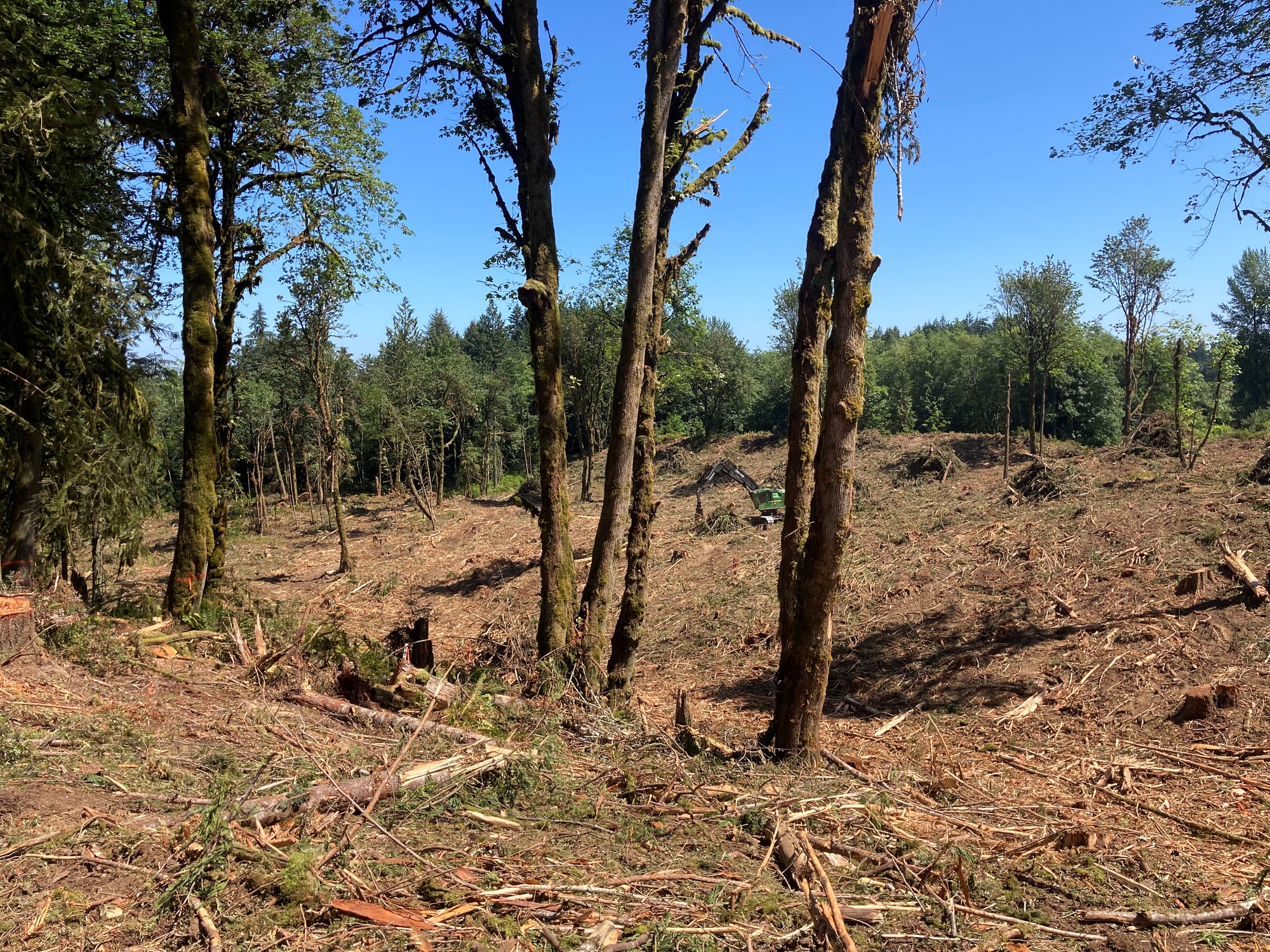
Cooper Crest forest is no more
Until the last week of this July, there was a forest of 80– to 100–year–old trees in a residential neighborhood, on Cooper Point Road between 20th and 28th Streets. “Cooper Crest” was a legacy forest, thriving in the middle of Green Cove Basin on a steep hillside alive with springs that supply Green Cove Creek. A 25–acre stand of Douglas Firs and cedars presided over a critical area for aquifer recharge, provided habitat for diverse species, stabilized slopes to reduce landslides—and contributed to slowing global warming by sequestering carbon.
DNR issues a quick permit
That forest is gone now, clearcut by the investors of Silvimantle LLC under a permit granted by the state Department of Natural Resources (DNR). The private landowner was able to gain DNR approval for the permit in less than a month, overriding a plan for the area adopted by Olympia and Thurston County in 1998, and based on a map that falsely eliminated one of two streams on the property. By accepting the doctored map, DNR gave the investors a gift of public land, allowing them to log in a riparian area that would otherwise have required protection.
Silvimantle bought the northern 17 acres of the property in March 2021 for $150,000 then bought an adjoining parcel in May 2022, giving them the 20+ acres needed to apply for a DNR logging permit. Marty Wickland, a representative of Silvimantle, quoted in the online journal JOLT on August 5, claimed his group had wanted to sell the property intact but couldn’t find a buyer.
Time to get the money
“At the end of the day, we ran out of time for our investors. We have four of them and they were all like, ‘Hey, we need to get our money back.’ The log market’s very strong. And we needed to move forward,” Wicklund said. [Who will repair the damage? See box at the end of this article.]
They came in and clearcut the trees before the period for appeal was over. The community surrounding the site became aware of the project only after a two–week comment period ending May 27 had passed, denying the public any opportunity to weigh in. The City of Olympia however, had provided comments, disputing data presented in the Forest Practices Application (FPA) that DNR used to issue the logging permit.
City of Olympia shut out
The City noted that, while Silvimantle’s Application claimed there was only one stream on the property, there were, in fact, two. Both were shown on a Department of Fish and Wildlife study that had been done for a project proposed previously for the site, and on DNR’s own map. Other discrepancies the city noted were that this was a fish–bearing stream, and that there were three wetlands on site, not the one claimed on the Application. City records also documented five landslide hazard areas that were not considered in the FPA. The city also noted that DNR should have coordinated with its own geological division to access internal data showing the site was geologically, hydrologically and seismically unstable.
The 1998 Green Cove Plan recommended an increase in the tree canopy and a decrease in the amount of stormwater runoff that contributed to downstream flooding that had always been a problem. The high–pressure aquifer recharge area on the site supports several critical wetlands and tributaries that support in–stream flow for threatened salmon in Green Cove Creek and help supply the City’s Allison Springs Well, hundreds of private wells and the Strategic Groundwater Reserve for the State Capitol.
How did two streams on a map become only one?
The original Forest Practices Application showed two streams. Then, on a revision dated May 26 the stream segment that cuts through the northern part of the property was crossed out with X’s and labeled “DNE “— meaning “does not exist.” There was no written documentation to support elimination of the stream segment, despite the fact that DNR has a process to update water typing maps. Claims by Silvimantle that no stream channels had been found in this area don’t reflect the fact that the evaluation was not done during the rainy season or that the area was overgrown with brush that could conceal evidence of the stream bed.
A gift that keeps on giving
Land surrounding streams and wetlands qualify as riparian areas. These enjoy greater protection from logging since they are essential to the integrity of watersheds. These aquatic resources ultimately belong to the State; a practice that allows logging from these areas amounts to a “gifting” of public lands to private interests.
With a stroke of the pen, Silvimantle obtained this gift and so was able to bulldoze a logging road through the area of the map where the stream was located—concealing the fact that the tributary ever existed.
Silvimantle claims that altering an official map in this way is a “common practice” in the natural resources world. If that’s so, it appears that DNR’s failure to stop the practice may compromise watersheds statewide.
Will an appeal stop this “common practice?”
In an effort to shine a light on DNR policies that allowed this to happen, more than 100 individuals and five organizations signed on to a June 27 appeal of the Forest Practice Application, filed by the authors of this article. It was amended on July 7 to request a statewide stay on the practice of altering official maps.
The amended appeal and stay states that crossing out the mapped stream at Cooper Crest “…appears to be based upon an unwritten, unlawful custom, policy or procedure to allow a “gifting” by state government to private forest landowners of state aquatic land and riparian zone areas, as well as the gifting of federal resources of the United States, in this case, a half mile of Green Cove Creek, its headwaters, and its endangered and threatened fish and wildlife. This custom—to allow private landowners to steal federal and state resources with the aid of Department of Natural Resources and Department of Fish and Wildlife agents and the Attorney General by altering, and thereby tampering with an official document… appears to occur statewide.”
And pay for the damage done
Forest Practice Applications are appealed to the Pollution Control Hearings Board (PCHB). The amended appeal and stay asks for injunctive and compensatory relief. Injunctive relief would be to stop the practice of crossing out streams without process or documentation; as well as mandating state agencies to review all evidence held by state and local officials before approving permits.
Compensation is requested for damage to the property and to downstream infrastructure in the Green Cove Creek Basin and Butler Cove watersheds due to stormwater runoff, flooding and landslides; as well as to fish and wildlife habitat. Displaced bears, cougars and coyotes have recently been sighted in the Goldcrest neighborhood next door.
The PCHB has issued an Order to show cause why the appeal should not be considered moot since Silvimantle has already clearcut the forest. Appellants responded that the practice of altering official maps is likely to recur, that adjudication is of statewide public interest and that the PCHB could award damages. PCHB will likely rule by September on whether the appeal will go forward.
Esther Kronenberg and Jerry Dierker have studied and researched the Green Cove Watershed and taken responsibility for its protection.
Real investors vs speculatorsOlyEcosystems, a local non–profit, focuses on strategic acquisition of open space, ecosystem restoration and advocacy. They were able to purchase the Cooper Crest property from Silvimantle for $225,000 with the support of the Angela J. Bowen Conservancy Foundation—making an investment that promises to offer dividends for the future of our community. What took a hundred and more years to produce—with myriad benefits for the climate, the habitat, and the people who live here—was eliminated in five days, with benefits of several hundred thousand dollars to just four investors. OlyEcosystems will start what promises to be a long commitment by doing critical erosion control and then taking on the task of planting 350 trees per acre as required under the Forest Practices permit. Planting needs to occur by the end of the year to benefit from winter moisture. OlyEcosystems is a community effort. Visit their website to volunteer or donate. |

Be First to Comment